The Celestial Sphere
The rising and setting points of celestial bodies (sun, moon, stars, and planets) are determined by their positions on the celestial sphere.
The celestial sphere is an imaginary sphere with the earth at its center. The sky overhead is the half of the sphere we see from earth, appearing as a dome (even though the sky extends infinitely into space). The other half of the sphere is below the circle of the horizon.
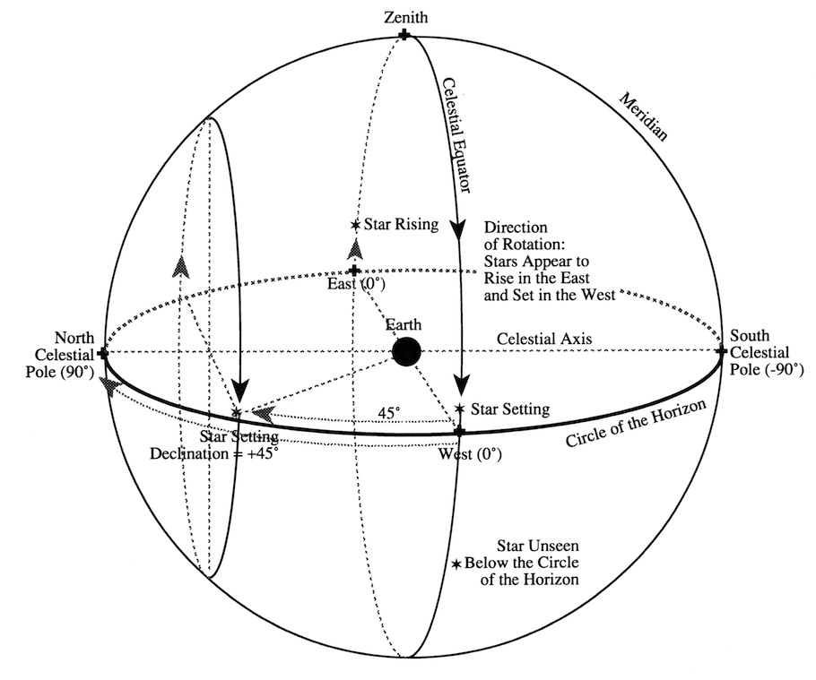
The sphere appears to be rotating from east to west every twenty-four hours, so celestial bodies appear to rise in the east and set in the west. (The earth’s rotation creates the illusion that the celestial sphere is rotating.)
The Celestial Sphere “rotates” on the Celestial Axis, which goes through earth’s north and south poles and extends out to the Celestial Sphere intersecting it at the North Celestial Pole (NCP) and the south Celestial Pole (SCP).
The Celestial Equator is an imaginary line around the middle of the Celestial Sphere, equidistant from the NCP and SCP and on the same plane as the earth’s equator. It intersects the Circle of the Horizon at East and due West.
Orienting the Observer to the Celestial Sphere Using Other Imaginary Lines and Points.
The Circle of the Horizon surrounds the earth-bound observer, who is standing in the middle of it. Points on the horizon are called directions. The horizon circle is divided into 360°s, with 90°s between each of the four cardinal directions of North, South, East, and West.
The Zenith is the point on the Celestial Sphere directly above the observer.
The Meridian is an imaginary circle passing through the Zenith and NCP and SCP and is always perpendicular to the horizon.
Position of Stars on the Celestial Sphere
Stars appear fixed on the Celestial Sphere as it rotates. Their coordinates are given in two numbers, Declination and Right Ascension, which represent imaginary lines, like latitude and longitude on the earth’s surface. The intersection of the Declination and Right Ascension lines gives a point that represents the position of a body on the Celestial Sphere.
1. Declination equals the angle of a star away from the Celestial Equator with the vertex (the common endpoint of the angle) being the center of the earth). A celestial body on the Celestial Equator has a declination of 0 and rises due East and sets due West. (The sun at Vernal and Autumnal Equinox has a declination of 0.)
Celestial bodies to the north of the Celestial Equator have positive declinations of up to +90°s, which is the declination of the NCP. Hokupa‘a, the North Star, near the NCP, has a declination of +89.3°s. With the observer at the equator, a star with a declination of +45°s would rise in the NE and set in the NW. (See Chart Above.)
Celestial bodies south of Celestial Equator have negative declinations of up to –90°s, which is the declination of the SCP. With the observer at the equator, a star with a declination of – 45°s would rise in the SE and set in the SW.
2. Right Ascension [RA], gives the position of a celestial body in relationship to lines from the NCP to the SCP, intersecting the Celestial Equator halfway in between at right angles. (These lines are like longitude lines, which run between the North and South Poles on Earth and intersect the Earth’s Equator perpendicularly.)
The zero point for RA on the Celestial Equator is the position of the sun at vernal equinox, called the vernal point. RA is given in hours (h) and minutes (m), with 0 and 24h equal to the same point. 24 hours is used because the earth is rotating, once every 24 hours, which equals one revolution of the Earth / Celestial Sphere / Celestial Equator.
One hour = 15°s. So a star at the horizon rising in the East will take one hour to rotate up on the Celestial Sphere 15°s above the Eastern Horizon; 24 hours later it will be back rising in the East. A star 15°s above the Western horizon on the Celestial Equator will take one hour to reach the Western horizon and set.
At the vernal point, the sun is near the constellation of Pisces on the Celestial Sphere. Stars in this constellation have a RA near 0. Omega Piscium, for example, has an RA of 23h 59m, almost at 0. A star on the opposite side of the celestial sphere have RAs around 12h. For example, Denebola, in the constellation Leo, the house of the sun at fall equinox, has a RA of 11h 49m.
How the Latitude where the Observer is Located Affects the Rising and Setting of Stars
At the Equator (middle diagram in the chart below) the Celestial Equator intersects the Circle of the Horizon at a right angle and celestial bodies appear to rise and set perpendicularly. The NCP and SCP are on the horizon, due North and South. The stars around the NCP and SCP appear to rise and set in half circles, above the horizon for 12 hours.
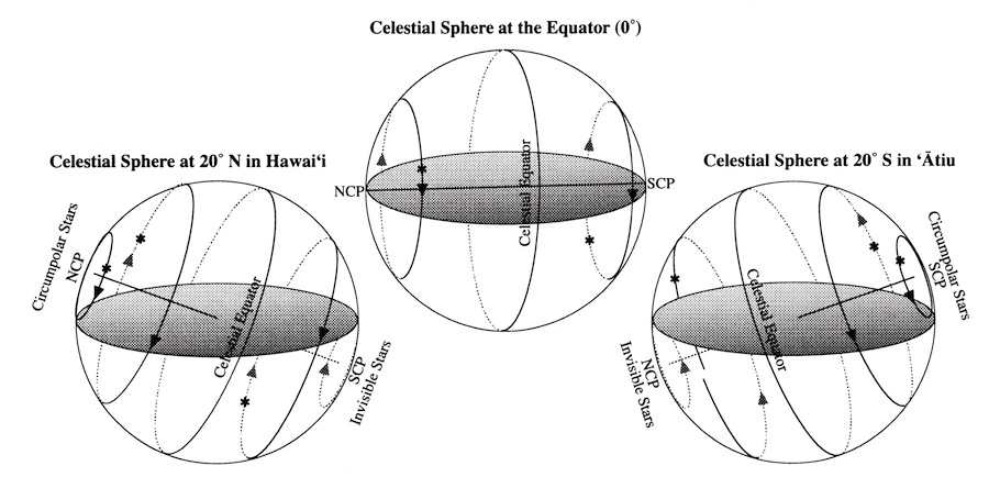
As the observer moves farther north from the equator, the curvature of the earth reveals more and more of the sky around the NCP and less and less of the sky around the SCP. The angle of the Celestial Equator tilts to the south in relationship to the plane of the horizon. The angle of the tilt is equal to the latitude of the observer. Thus in Hawai‘i, at 20° N (left diagram in the chart above), the Celestial Equator is tilted 20° toward the south. The NCP appears 20° above the horizon due north, while the SCP is unseen, 20° below the Horizon due south.
Moving south from the equator has the opposite effect (right diagram in the chart above, at 20° S, in for example, ‘Atiu, in the Cook Islands.) The angle of the Celestial Equator in relationship to the plane of the horizon tilts 20° toward the north. The SCP appears 20° above the horizon due south, while the NCP is unseen, 20° below the horizon due north.
Circumpolar Stars
At 20° N, celestial bodies with declinations within 20° of the NCP (i.e. +70 to +90°s) will no longer rise or set. They appear to be circling the NCP and are called circumpolar.
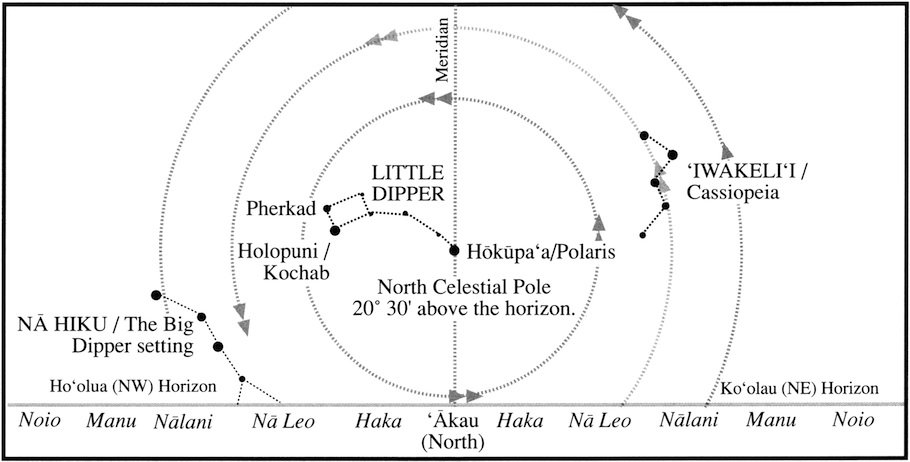
Holopuni (Kochab), with a declination of +74°, is circumpolar.
Celestial bodies with declinations within 20° of the SCP (i.e. –70 to –90°s) cannot be seen at 20° north in Hawai‘i, as they circle the SCP below the horizon, unseen, without rising or setting.
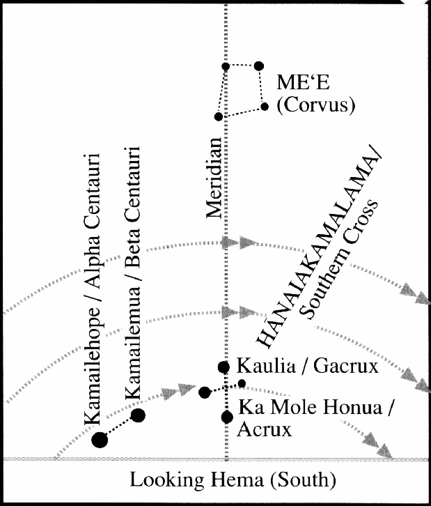
Because the SCP is 20° below the horizon, stars that rise and set near south move across the sky in low arcs rather than half circles:
As the observer continues toward the NCP from 20° north, more and more of the stars around the NCP become circumpolar, and less and less of the sky around the SCP is seen. At the north pole, all celestial bodies (0 to +90° declinations) are circumpolar, traveling around the observer without rising or setting, like animals on a merry-go-round; and all celestial bodies, with 0 to – 90° declinations, would remain unseen, circling the SCP below the horizon.
Due to the tilting of the Celestial Sphere and Equator relative to the horizon when the observer is north or south of the earth’s equator, celestial bodies appear to rise and set at an angle. (Their rising and setting are always parallel to the celestial equator.) The angle is equal to the latitude of the observer. At 20° N, a celestial body will rise at an angle 20° south (to the right) from a perpendicular line intersecting the horizon at the point where the star rose from the horizon; a celestial body will set at an angle 20° S (to the left) from a perpendicular line intersecting the horizon at the point where the star will set at the horizon.
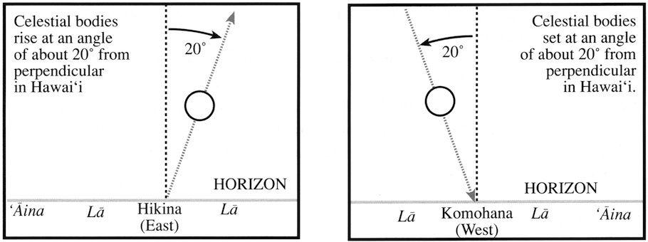
At the equator, the declination of a celestial body equals the angle away from east and west (i.e. the direction in degrees) at which it rises and sets. As the observer moves north or south of the equator, the angle away from east and west that a celestial body rises and sets increases for celestial bodies toward the NCP and SCP. Thus, a celestial body that rises at NE by N and sets at NW by N at the equator, rises at NNE (rather than NE by N) and sets at NNW (rather than NW by N) at a higher latitude.
How Earth’s Orbiting the Sun Affects the Sun‘s Position on the Celestial Sphere.
As the earth orbits the sun over the year, the sun appears to move on the celestial sphere against the background of the fixed stars. (Another illusion: it’s the earth and the observer moving around the sun rather than the sun changing its position.) The curving path the sun seems to follow is called the ecliptic, which passes through a series of twelve constellations called the Zodiac.
Because the earth is tilted at a 23.5° angle, the path is not straight; it has two curves in it. From March to September, the sun appears to be north of the Celestial Equator, among the constellations of Pisces, Aries, Taurus, Gemini, Cancer, and Leo. From September to March, it appears south of the Celestial Equator, in the constellations of Virgo, Libra, Scorpio, Sagitarius, Capricorn and Aquarius. The sun’s position crosses the Celestial Equator at Spring and Fall Equinox.
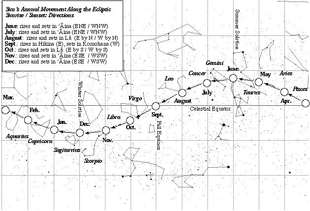
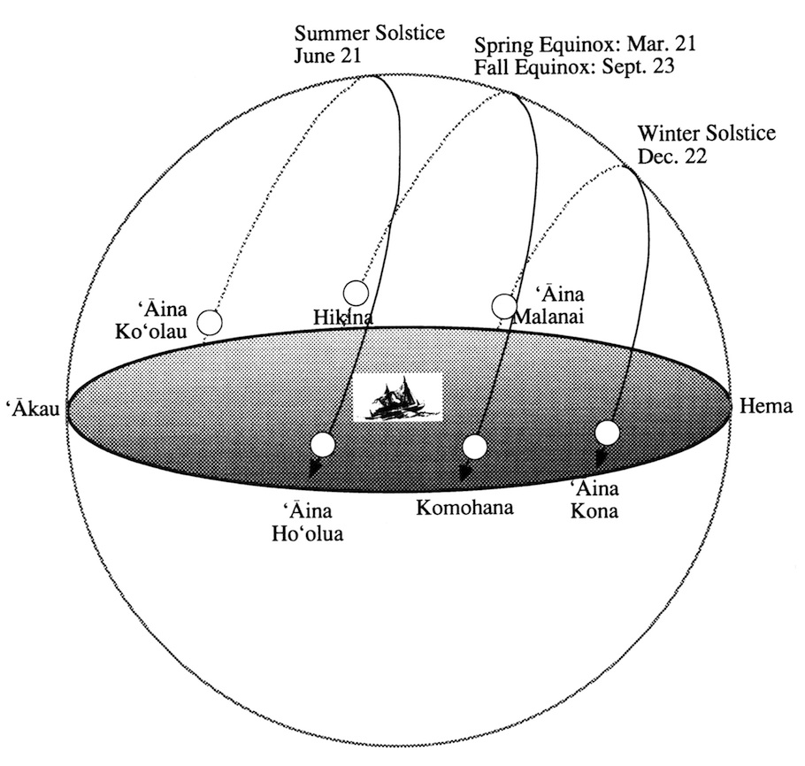
Because the position of the sun in relationship to the Celestial Equator changes over the year, so does its declination and rising and setting point on the horizon. At spring and fall equinox the sun has a declination of 0 and rises due East and sets due West. At summer solstice, when the sun is at its farthest position north of the Celestial Equator, it rises at ENE (‘Aina Ko‘olau in the chart below) and sets at WNW, with a declination of +23.5°. The 23.5° maximum for the position of the sun at rising and setting is equivalent to the tilt of the earth on its axis. At winter solstice, when the sun appears to be south of the Celestial Equator, the sun rises at ESE and sets at WSW, with a declination of –23.5°.
The sun rising at different times of the year in Hawai‘i
How the Moon’s Orbiting the Earth Affects the Moon‘s Position on the Celestial Sphere.
As the moon orbits the earth, its position, like the sun’s, changes on the Celestial Sphere. Like the sun, the moon’s position appears to travel along the path called the Ecliptic, through the twelve constellations of the Zodiac. Unlike the sun, which takes a year to complete its journey, the moon completes its journey through the zodiac in 29.5 days – the time it takes for it to orbit the earth once. It deviates from the ecliptic on either side by about 5°s, crossing it twice.
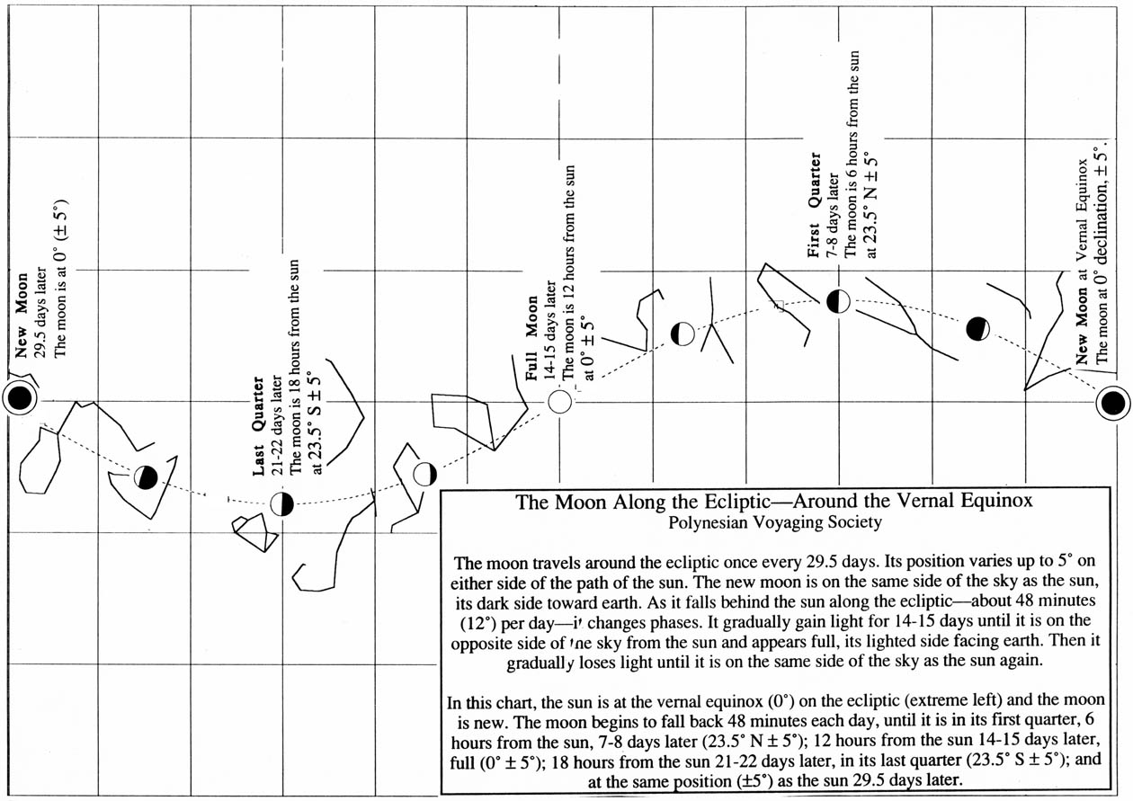
As it passes around the earth on the ecliptic, the amount of sunlight the observer on earth sees on the moon’s surface depends on where the moon is in relationship to the sun and the observer. When the moon is on the opposite side of the sky from the sun, with the observer in between, the moon appears fully lit by the sun; when the moon moves away from the sun, it appears less than full. When it is on the same side of the sky as the sun, between the observer on earth and the sun, the observer sees the unlit side of the moon and it appears dark. As it moves closes to the sun again, it begins to lose its fullness. (See The Hawaiian Lunar Month.)
As the moon’s position shifts north and south of the Celestial Equator along the ecliptic on its 29.5 day cycle, it rises and sets about 48 minutes later each night, at a different position on the horizon from where it rose the night before. Its rising point moves back and forth between ENE (‘Aina Ko’olau) and ESE (‘Aina Malanai); its setting point between WNW (‘Aina Ho’olua) and WSW (‘Aina Kona).
The moon’s position on the celesital sphere can be determined with the help of the fixed stars, that is, by observing where the moon is in relationship to the stars around it. Once its position is determined, the moon can be used in navigation.
The Planets
The planets (“wanderers”), orbiting the sun, like the sun and moon, appear to move among the fixed stars over time; hence, their Hawaiian names hoku hele, “Traveling Stars”, or hoku ‘ae’a, “Wandering Stars.” Their rising and setting points can be determined from nearby stars; they can be used for navigation once their positions have been determined.
The Hawaiian names for the visible planets are:
- Mercury: Ukaliali’i (“Following the chief,” i.e. the Sun)
- Venus: Hokuloa (“Long Star”), Hokuao (“Morning Star”), Hokuahiahi (“Evening Star”), Hokuali’i (“Chiefly Star”), Hokuali’iwahine (“Chiefly [female] Star”)
- Mars: Hoku’ula (“Red Star”), Holoholopina’au, ‘Aukelenuiaiku (“Great travelling swimmer, son of Iku”)
- Saturn: Makulu (“A drop of mist”)
- Jupiter: Aohoku (“Starlight”), ‘Iao (“Dawn”), Ikaika (“Strong,” “Powerful”)
The planets orbiting the earth closer to the sun than earth (i.e., Mercury and Venus) appear near sun in the sky. When it sets after the sun, Venus is known as the Evening Star in the west; when it rises before the sun, it’s called the Morning Star.
Geography and Direction
To be guided to a destination by the stars, a navigator needs to have a method to steer his canoe by the stars in order to hold a course; and he needs to know in what direction his desintation lies in relationship to his present location. Before leaving, he designs a course strategy for getting to that desintation.
Hawaiian Terms for the Celestial Sphere
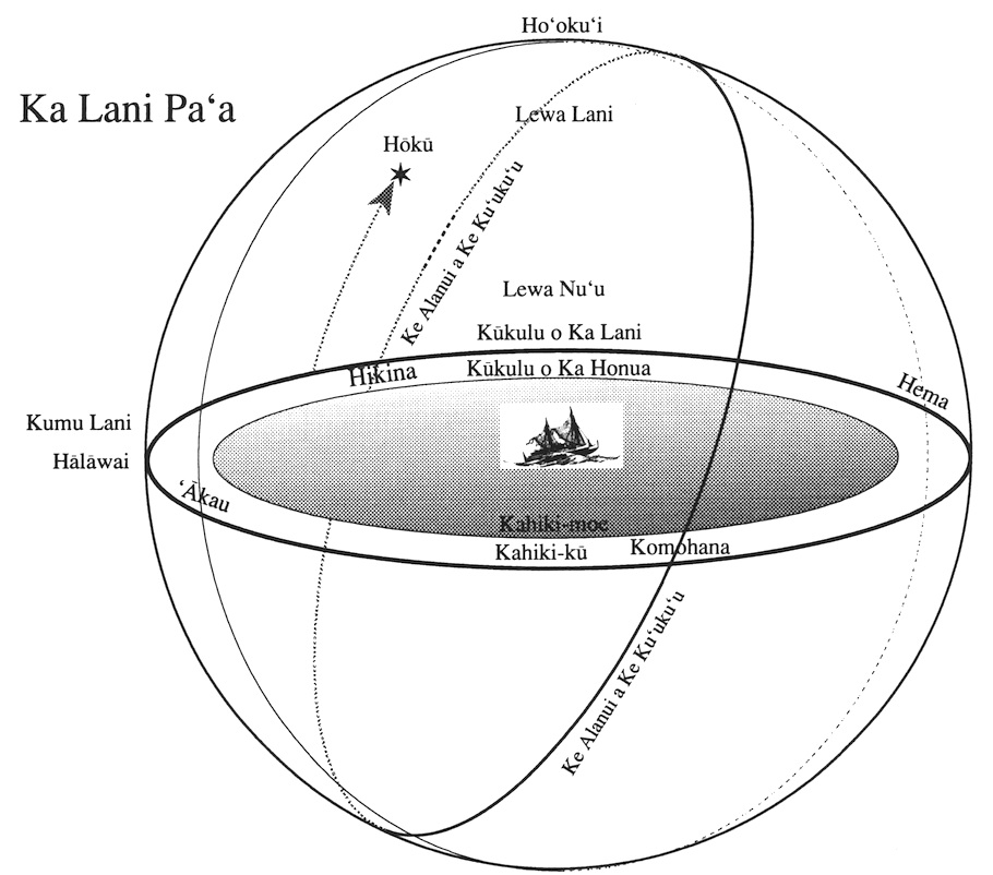
Ka Lani Pa’a = the Celestial Sphere; lit., “solid sky”; also, the highest space above.
Luna-ae = space above one’s head; above that, luna aku; above that, luna-loa-aku; above that, luna-lilo-aku; above that, luna-lilo-loa; above that, where the clouds float, luna-o-ke-ao, above that three divisions: ke aouli (“blue sky”), ke laniuli (“blue heaven”), and ka lanipa’a (Malo 12).
Lani refers to the heavens; Lewa, the space between heaven and earth; lewa-lani = space beneath the heavenly dome; beneath that, lewa-nu’u, “elevated space,” or space where the birds fly; below that lewa-lani-lewa.
Kumu Lani = base of heaven, where the sky joins the earth.
Kahiki-moe = circle of the visible horizon.
Kahiki-ku = first band of the sky dome as it rises up from the earth; islands and clouds above and beyond this band are in realms called Kahiki-papa-nu’u, Kahiki-ke-papa-lani, Kahiki-kapu-i-holani-ke ku’ina (Malo 10).
Kukulu o ka Honua = compass or border of the earth Kukulu o ka Lani=border of the sky; where the wall of the sky joins the ocean.
Ke Alanui a ke Ku’uku’u = “The Roadway of the Spider”; Celestial Equator
Ho‘oku‘i = Zenith, lit. “joined” [where the walls of heaven meet, directly overhead]. Kamakau says Ka Ho’okui, the juncture, was “equidistant from the sky downward and the earth upward.”
Halawai = Horizon, lit. “meeting” [where the sky meets the earth].
The celestial bodies appear to emerge from holes (puka) in the horizon: Hence the phrase “puka mai ka la,” “The sun emerges or appears [from a hole].”
Ke ala hoku, the path of the stars, were seen as posts or pillars supporting the roof of heaven.